Nankai Trough Megathrust Earthquake (Mechanisms, Historical Cycles, and Disaster Preparedness)

The Nankai Trough Megathrust Earthquake is a maximum-class seismic event that has the potential to inflict catastrophic damage on the Japanese archipelago, representing a true "national crisis."
To prepare for this inevitable event, it is vital to build a correct understanding of its physical mechanisms, anticipated damage fields, and home disaster safety plans.
Based on the latest seismology research, this article provides a detailed guide to understanding and preparing for the Nankai Trough Megathrust Earthquake.
Definition and Tectonic Mechanism of the Nankai Trough Earthquake
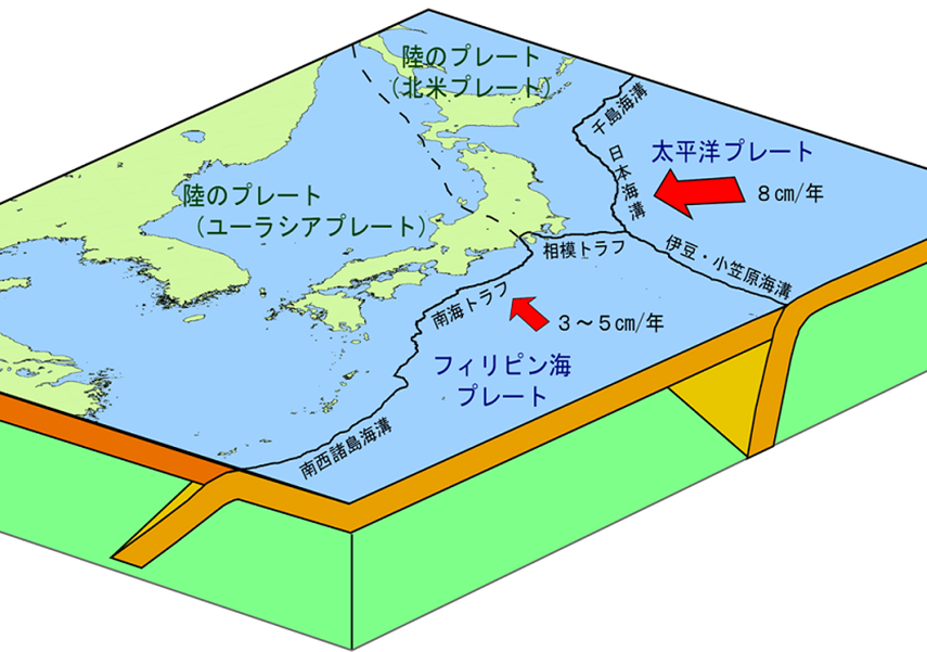
The Nankai Trough Megathrust Earthquake refers to a massive subduction-zone earthquake occurring along the Nankai Trough, the plate boundary where the Philippine Sea plate subducts beneath the Amurian (Eurasian) plate. The anticipated epicentral region spans a vast oceanic zone from Suruga Bay in Shizuoka Prefecture to the Hyuga-nada Sea off Miyazaki Prefecture, with an estimated magnitude of 9.0.
These megaquakes have historically recurred at cycles ranging from roughly 90 to 265 years, with past events unleashing massive, destructive tsunamis along the coast.
The tectonic mechanism driving this earthquake involves the Philippine Sea plate subducting under the continental plate at a rate of several centimeters per year. This process bends the edge of the continental plate downward, accumulating immense elastic strain over decades. When this strain reaches its physical limit, the continental plate violently snaps upward, releasing accumulated energy as a massive earthquake and tsunami.
https://www.jma.go.jp/jma/kishou/know/jishin/nteq/nteq.html
Anticipated Focal Zone and Magnitude Scale
The anticipated rupture zone of the Nankai Trough Earthquake is exceptionally broad, extending from Suruga Bay to the Hyuga-nada Sea.
Seismological models anticipate a maximum magnitude class of 9.0, with intense Shindo 7 shaking expected in parts of Shizuoka, Aichi, Mie, Wakayama, Tokushima, Kochi, Ehime, Oita, and Miyazaki prefectures. Furthermore, coastal areas from the Kanto region to Kyushu are projected to be struck by massive tsunamis exceeding 10 meters in height.
The violent ground motion is expected to last for an exceptionally long duration of 2 to 3 minutes, with tsunamis propagating rapidly across both the Pacific Ocean and the Seto Inland Sea.
Historical Occurrences and Seismological Cycles
Over the past 1,400 years, the Nankai Trough has produced Magnitude 8-class megaquakes at recurring intervals of 90 to 265 years.
The most recent occurrences were the 1944 Showa-Tonankai earthquake and the 1946 Showa-Nankai earthquake. Over 70 years have elapsed since these twin events, indicating that the probability and urgency of the next Nankai Trough megaquake are extremely high.
A key characteristic of Nankai Trough earthquakes is the high diversity in their rupture patterns and epicentral expansion.
Historically, some events ruptured the entire plate boundary simultaneously, while others occurred as "time-lagged twin earthquakes" where a massive rupture on the eastern half of the trough was followed hours, days, or even years later by a second massive rupture on the western half.
For example, during the Showa cycle, the eastern Tonankai segment ruptured in 1944, and the western Nankai segment ruptured roughly two years later in 1946.
| Year | Magnitude | Rupture / Affected Area | Key Characteristics |
|---|---|---|---|
| 1361 | M 8.2-8.5 | Off Cape Ashizuri to Cape Omaezaki | Shohei earthquake. Massive tsunami damage. |
| 1605 | M 7.9 | Nankai Trough / Izu-Ogasawara | Keicho earthquake. Weak shaking, but generated a catastrophic tsunami (Tsunami earthquake). |
| 1707 | M 8.6 | Entire Nankai Trough | Hoei earthquake. Simultaneous rupture from Tokai to Shikoku. Maximum class in historical records. |
| 1854 | M 8.4 | Off Enshu-nada to Suruga Bay | Ansei-Tokai earthquake. Followed 32 hours later by the Nankai rupture. |
| 1854 | M 8.4 | Off Nankaido segment | Ansei-Nankai earthquake. Inflicted massive tsunami damage on Kochi and Shikoku. |
| 1944 | Mw 8.1 (M7.9) | Eastern Kii Peninsula Offing | Showa-Tonankai earthquake. Fault slip terminated west of Cape Omaezaki. |
| 1946 | Mw 8.1 (M8.0) | Off Cape Shionomisaki | Showa-Nankai earthquake. Rupture zone extended westward to the Tosa Basin off Shikoku. |
Diversity of Rupture Scenarios in the Nankai Trough
A closer analysis of historical Nankai Trough earthquakes reveals that the plate boundary does not simply repeat the exact same rupture pattern.
For example, the 1944 Showa-Tonankai earthquake and the 1854 Ansei-Tokai earthquake experienced different shaking distributions, suggesting that different segments of the plate boundary locked and failed. Furthermore, the 1707 Hoei earthquake stands as the largest known historical event, unleashing catastrophic tsunamis that devastated the western coastline of Japan.
Because each Nankai Trough cycle manifests unique rupture characteristics, predicting the exact scale, timing, and damage pattern of the next event remains highly difficult.
Long-Period Ground Motion
When a megaquake occurs, it releases not only short-period seismic waves (the rapid, violent rattling) but also "Long-Period Ground Motion" (長周期地震動)—slow, rolling waves similar to being on a boat.
Long-period waves are easily generated by shallow, Magnitude 7+ earthquakes, and they travel exceptionally far with minimal attenuation compared to short-period waves.
Every building possesses a natural vibration period (natural period) that increases with its height. High-rise buildings with long natural periods resonate with these long-period seismic waves, causing the upper floors of skyscrapers to sway violently and persistently. This resonance can cause severe structural damage, shatter windows, and violently throw heavy furniture across offices and residences, posing critical hazards.
Tsunamis and Secondary Hazard Assays
In addition to intense shaking, a Nankai Trough megaquake will trigger catastrophic tsunamis.
These waves will strike not only the Pacific coasts but will also propagate deep into Osaka Bay and the Seto Inland Sea. Furthermore, the shaking will trigger widespread secondary disasters, including building collapses, urban fires, soil liquefaction, and massive landslides.
Lifeline disruptions will be severe. According to Cabinet Office estimates, a maximum-class Nankai Trough earthquake would cut water access for roughly 34.4 million residents and disrupt sewerage systems for up to 32.1 million people.
Electricity grids would experience blackouts affecting 27.1 million households, and city gas supplies would be cut for up to 1.8 million homes. Transportation networks (highways, railways, and ports) would suffer heavy structural damage, paralyzing logistics and requiring months for restoration.
Disaster Preparedness and Survival Protocols
To mitigate the impact of the Nankai Trough megaquake, implementing these individual safety actions is critical:
- Furniture and Appliance Anchoring: Secure all heavy furniture and appliances with brackets or straps to prevent crushing injuries.
- Emergency Grab-and-Go Bag: Prepare a survival kit containing vital medicines, portable radios, flashlights, and personal documents.
- Food and Water Stockpiles: Store at least a 7-day supply of drinking water (3 liters per person per day) and non-perishable food.
- Evacuation Zones and Routes: Pre-map local tsunami evacuation towers, high ground, and safe walking pathways.
- Structural Seismic Reinforcement: Perform seismic assessments on homes built before 1981 and apply necessary structural reinforcement.
- Community and Family Drill Plans: Coordinate family communication methods (such as the 171 message board) and establish mutual aid networks within neighborhoods.
It is essential that national governments, municipal bodies, private businesses, and local communities execute coordinated mitigation plans. Regular evacuation drills and public awareness campaigns are also critical to keeping disaster awareness sharp.

【PR】いざという時のための防災セット
・38品目全 44アイテムで準備万端
・72時間分の備え
・防災マニュアル付きで安心
・安心のサバイバルセット
Conclusion
The Nankai Trough Megathrust Earthquake presents an immense threat to the Japanese archipelago.
However, continuous household safety preparations can dramatically mitigate injuries and loss.
Due to the vast tectonic complexity of the Nankai Trough boundary, the next earthquake involves high uncertainty regarding rupture scale, segment triggers, and exact timing.
Precisely because of these uncertainties, it is paramount that we prepare for every potential scenario, establishing a highly flexible and comprehensive network of disaster safety measures.
About "Nankai Trough Megathrust Earthquake (Mechanisms, Historical Cycles, and Disaster Preparedness)"
This page provides the English definition and usage guide for the professional term "Nankai Trough Megathrust Earthquake (Mechanisms, Historical Cycles, and Disaster Preparedness)." If you have any suggestions, feedback, or corrections regarding our terminology articles, please feel free to reach out via our contact form.